Territories
and special areas of interest
IMPERIAL TERRITORIES, SPECIAL AREAS OF INTEREST & MISSIONS
The Geographic Reach of the Confederated Empire
The Confederated Empire of Bir Tawil and Territories maintains a network of Imperial territorial claims, foreign missions, Imperial courts, dependencies, and special areas of interest extending across several regions of the world.
IMPERIAL TERRITORIES & TERRITORIAL CLAIMS
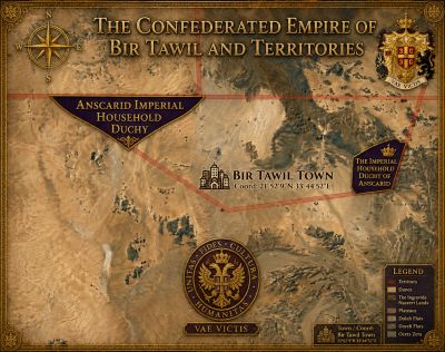
ANSCARID — IMPERIAL TERRITORY WITHIN BIR TAWIL
Region: Bir Tawil, Northeast Africa
Status: Foundational Imperial Territorial Claim
Imperial Designation: Anscarid
Boundaries: As delineated on the official Imperial Map of Bir Tawil
The Confederated Empire does not claim the entirety of Bir Tawil.
The Empire's foundational territorial claim consists specifically of the areas within Bir Tawil delineated on the official Imperial Map of Bir Tawil.
These mapped lands constitute Anscarid, the foundational African territory of the Confederated Empire and the geographic center of the Empire's original territorial project.
The official Imperial map defines the extent of the claim and shall serve as the authoritative geographic reference for determining which portions of Bir Tawil are included within the Imperial territorial system.
JENNSLAND
The Antarctic Imperial Claim
Region: Antarctic Peninsula and surrounding islands
Status: Imperial Territorial Claim
Imperial Designation: Jennsland
Jennsland is the name of the Confederated Empire's Antarctic claim.
The Imperial claim encompasses designated areas of the Antarctic Peninsula where research stations are not established, together with unoccupied islands off the coast of the Peninsula, as defined by the Empire's geographic records.
Jennsland forms the principal polar territory of the Empire and is associated with the Empire's interests in exploration, environmental observation, cartography and scientific research.
MACHIAS SEAL ISLAND
Region: Gulf of Maine
Status: Imperial Territorial Claim
Imperial Designation: Hereditary Dukedom
Machias Seal Island forms part of the territorial claims of the Confederated Empire and is constituted within the Imperial system as a hereditary Dukedom.
IMPERIAL FOREIGN MISSIONS
DUCHY OF KARISSA
Imperial Foreign Mission to the State of New Mexico
Region: New Mexico, United States
Status: Imperial Foreign Mission
Imperial Designation: Duchy of Karissa
The Duchy of Karissa is the Confederated Empire's claimed Foreign Mission to the State of New Mexico.
Centered near Moriarty, the Mission is intended as a physical center for Imperial development, sustainable construction, exploration, research and community activity.
Its planned development includes small residential structures, solar energy, gardens, water and sanitation infrastructure, desert research and activities of the Imperial Exploration Corps.
IMPERIAL FOREIGN MISSION TO THE PEOPLE OF CHIAPAS
Region: Chiapas, Mexico
Status: Imperial Foreign Mission
The Imperial Foreign Mission to the People of Chiapas serves as a center for the Empire's humanitarian, cultural and community activities in southern Mexico.
Its work includes humanitarian assistance, education, environmental projects, cultural engagement and continuing relationships with local communities.
IMPERIAL COURTS & ADMINISTRATIVE SITES
IMPERIAL COURT — SEDRO-WOOLLEY
Region: Washington, United States
Status: Imperial Court
The Imperial Court at Sedro-Woolley serves as a physical seat of Imperial activity in the Pacific Northwest and forms part of the Empire's wider network of courts, missions and administrative sites.
SPECIAL AREAS OF IMPERIAL INTEREST
The Empire also maintains geographic interests connected with exploration, maritime development, scientific research and future Imperial projects.
These include Bermeja, New Byzantium, Operation Poseidon, Operation Osiris, and additional geographic areas designated by the Imperial Crown and Ministry of Exploration.
THE IMPERIAL GEOGRAPHIC NETWORK
The principal geographic components of the Empire currently include:
ANSCARID
The specifically mapped Imperial territories within Bir Tawil.
JENNSLAND
The Empire's claim encompassing designated portions of the Antarctic Peninsula and offshore islands without established research stations.
MACHIAS SEAL ISLAND
The Imperial territorial claim and hereditary Dukedom in the Gulf of Maine.
DUCHY OF KARISSA
The Imperial Foreign Mission to the State of New Mexico.
IMPERIAL FOREIGN MISSION TO THE PEOPLE OF CHIAPAS
The Empire's active mission in southern Mexico.
IMPERIAL COURT AT SEDRO-WOOLLEY
The Empire's Imperial Court in Washington State.
Together with the Empire's maritime, exploratory and scientific projects, these locations constitute the present geographic network of the Confederated Empire.
VAE VICTIS
THE CONFEDERATED EMPIRE OF BIR TAWIL AND TERRITORIES